Located on the northwestern border of Hunan Province, Zhangjiajie city features a variety of different terrains including: mountainous regions, upland areas, plains, and karst rock areas. Among these, the mountains cover 76 percent of the total area, and the world-famous natural heritage site "Wulingyuan Scenic Area"is located on the base of these great mountains. The scenic area also includes Zhangjiajie National Forest Park, known as China's first national forest park, Suoxiyu National Resource Reserve, and Tianzi Mountain Natural Resource Reserve. They enjoy the reputation of "Original Picture on Mountain and River of China", and this wonderland is covered with dense forests and is considered Mother Nature's Oxygen Bar.
Detailed Zhangjiajie Scenic Area Map
Here is a detailed and clear tourist map of Zhangjiajie, which is highly focused on not only mapping the locations of all scenic areas, but also showing the tourist routes, essence tourist routes and cables. The vivid pictures and clear tourist routes and sites can greatly help you find the famous attractions, such as Wulingyuan Scenic Area, the Peculiar Stone Bridge, etc. In addition, it plots the distance between these scenic spots with Zhangjiajie City.
 [page]
Wulingyuan Scenic Area Map
Below is a simple and clear travel map of Wulingyuan Scenic Area, which is highly focused on how to have your tour in this area with mapping not only the main tourist sites such as Wulingyuan Town, Yellow Dragon Cave, Bao Feng Lake, etc, but also the tourist routes including the heavenly elevator, free bus routes, hiking routes and mini train ride and more. In addition, it marks the entrances and exits on this map which can help you find the right way easily and conveniently.
Wulingyuan is a scenic and historic interest area in Hunan Province, China, famous for its approximately 3,100 tall quartzite sandstone pillars, some over 800 meters in height, which are a kind of karst formation. It is part of Zhangjiajie city, about 270km from the capital of Hunan Province, Changsha. It was designated a UNESCO World Heritage Site in 1992. Wulingyuan forms part of the Wuling Range.

Sketch Travel Map of Zhangjiajie
This is a sketch map of Zhangjiajie Scenic Spots, showing the tour routes and major tourist attractions in this national top tourist destinations city.
 [page]
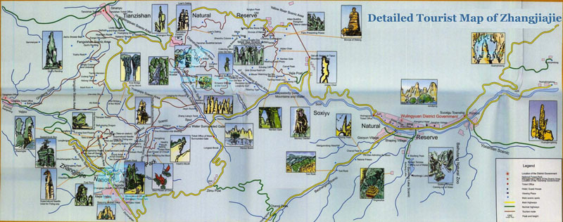
Detailed Travel Map of Zhangjiajie
There is a clear and detailed tourist map of Zhangjiajie, which not only shows the exact locations of all scenic spots, but also provides the travel information and guide vividly with beautiful pictures. Besides, it plots the transport conditions including railways, airways and highways. With this large and detailed map, you can have the clear idea of what the scenic area looks like even before you get there.